Get the Best IPTV Service
OTHER - Cannot Find Galaxy 19 FTA 97 West :( | SatelliteGuys.US

OTHER Cannot Find Galaxy 19 FTA 97 West :(

ILoveSats

SatelliteGuys Pro
Original poster
Jan 28, 2023
167
48
America
Hello Sat lovers!

I tried in vain for 6 hours today to find Galaxy 19 to no avail. Perhaps you guys can help me determine the issue?

Here is the equipment I am using:
  1. GeoSatPro 90cm reflector
  2. SatMaximum universal Single LNB (9.750/10.600)
  3. KOQIT H.265 HEVC Satellite receiver
  4. RG6 cable (3 feet)
  5. RCA Television monitor
  6. HDMI cable
  7. 1 Norwegian Elkhound

I used the DishPointer app to determine that I can see the Galaxy 19 satellite without obstruction. I then used the Dish Pointer app to acquire the settings I need to set the reflector accordingly. EG:
  • Elevation
  • Azimuth
  • LNB Skew

Setting up my receiver I followed this Youtube how-to as it relates to the same make and model I have:


I used the Dishpointer app to ensure:
a. Elevation by using my ipad as an inclinometer resting on the antenna branch​
b. Polarization by making sure I turned the LNB in correct direction and to right degree​
c. Azimuth ensured the dish was pointing in the right direction​
PROBLEM:

No TV or Radio channels are appearing when a Blind scan for FTA Ku band channels on Galaxy 19 are performed.

The reflector was set using the settings offered by Dish Pointer and the settings of the satellite receiver were set by following the Youtube video above.

The only thing I observed during a 'Blind' search (channel scan) was that the Strength was always at around 80% and the Quality was always at 0%. Even after a channel scan was performed the 'Strength' meter still displayed 80% Once in a while, I would see 'Quality' flicker momentarily but that was it. All my connections were checked and double checked.

The only thing I can think is that either the receiver is defective or the LNB is defective.

1. Is there a way to test if the LNB is defective?
2. How many degrees off from a satellite can you be and still have some level of signal quality appearing on the receiver dashboard?

Your thoughts and advice are very much welcome!

Thanks!

John


Welcome to Satellite Guys John! I've never use the Koqit receivers myself so I can't speak about them but the video you found seems to cover that very well. What the video doesn't speak of is the actual aiming of your dish which is a critical component of FTA reception.

Since you have the small tv and a three foot piece of coax I'm assuming you are actually out at your dish? That is great since you will need to make many small adjustments and running back and forth from your house to the dish will get tiresome very quickly. ;)

1. You appear to have done this but I'll mention it anyway. Double check that your receiver's lnb power is set to on and that your lnbf settings and skew are correct.

2. Make sure you are using a known good transponder in your receiver while aiming your dish. Is there a list of transponders already stored in your receiver for 97w? If not, add a transponder manually. Either way I would suggest using one of these known good transponders:

12152 H 20000
12028 H 22000
11966 H 21600
11842 H 20000
12084 V 20760
12053 V 22000

Once you have picked one the quality reading is what you need to focus on. The strength reading simply shows that you have an lnbf actually connected to your receiver.

3. Start by aiming your dish where you believe the satellite is using the data you acquired from Dishpointer.

4. Make a mark on your pole and mount with a pencil for the current azimuth and elevation.

5. SLOWLY move your dish east a TINY amount waiting at least ten seconds for the receiver to get a lock. Remember you are trying to hit a satellite located over 22000 miles out in space. A tiny fraction of an inch off and you will get nothing. If you don't see any quality reading move it a tiny bit more and continue this process until you have traveled to a point that you know the satellite is obviously not at. At this point move back to your starting mark and go west using the same procedure. If at any point you get a quality reading do a blind scan to determine what, if any, channels you can get.

6. If you still don't get a signal return to your starting point and raise your elevation a TINY amount. Repeat the above procedure in step 5. Still nothing? Return to your starting points and lower the dish in the same manner as above.

At some point if your receiver, lnbf and settings are correct you should hit a satellite and be able to blind scan some channels. Hopefully it will be the sat you want. If not you can at least use it to find which way you are off to adjust your dish. Good luck!

P.S. The Norwegian Elkhound should be good company while you are out at your dish! :)
 
Last edited:
Please add photos of your dish including a view of your LNB. Often a problem can be detected when others see your dish. For example, are you sure you are setting the LNB skew in the correct direction? Where approximately are you located.
 
  • Like
Reactions: FTA4PA
@FTA4PA

Thanks for responding to my post and offering additional insight.

Yesterday (1/28/23) was the first time I tried to set up a satellite reflector so there was tons to learn and figure out. My biggest concern was that the LNB was broken as I didn't find any satellites. Today, after some more research, I learned that when signal 'strength' is present this means the LNB is working. So I'll take that as good news.

I also found today the following:

In order for the receiver to detect the satellite, select an active KU band frequency from the transponder list. I prefer to use 12152MHz, Horizontal - Polarity, 20000 - Symbol Rate. This transponder is not duplicated on nearby satellites and will make 97w easier to identify.

Identify a landmark in the distance that lines up with the magnetic compass reading for the 97w satellite based on your location.

With a small TV next to the dish and while watching the Signal Quality meter reading, SLOWLY pan up to 15 degrees East and 15 degrees west of the identified landmark.

If no Signal Quality reading is detected, increase or decrease the dish elevation in one degree increments and SLOWLY pan the +/- 15 degree range while watching the Signal Quality meter reading.

Repeat until a SQ reading is detected and the reading optimized. Once the SQ reading is optimized, perform a blind scan of 97w.


A lot of what you pointed out above I was already able to take today into the field on my second attempt. Nonetheless, I still did not get locked onto Galaxy 19. However, there may be an explanation. As you will note from above its stated that:

"With a small TV next to the dish and while watching the Signal Quality meter reading, SLOWLY pan up to 15 degrees East and 15 degrees west of the identified landmark."

Where as your instructions state:

"SLOWLY move your dish east a TINY amount waiting at least ten seconds for the receiver to get a lock. Remember you are trying to hit a satellite located over 22000 miles out in space. A tiny fraction of an inch off and you will get nothing. "

Today, I was not stopping and waiting, I was rotating the reflector continuously in a very slow motion. Also, I was starting at the eastern most point and stopping at the western most point where I knew there was no satellite.

1. My new question is how much is a tiny fraction of an inch? Could I move at least 3mm and then stop and wait 10 seconds or do I need to make yet smaller increments like 1mm?
2. Would those $15 satellite signal finders help me in any way?

@
cyberham The dish pointer app has built in graphics that help you set correctly the skew etc... So I know they are correct. I can even use my ipad as a inclinometer when setting elevation. See attached.

Thanks Guys!​


Attachments

  • IMG_0030.PNG
    IMG_0030.PNG
    180.5 KB · Views: 186
  • Screenshot 2023-01-29 at 18.17.46.png
    Screenshot 2023-01-29 at 18.17.46.png
    162 KB · Views: 185
@FTA4PA

Thanks for responding to my post and offering additional insight.

Yesterday (1/28/23) was the first time I tried to set up a satellite reflector so there was tons to learn and figure out. My biggest concern was that the LNB was broken as I didn't find any satellites. Today, after some more research, I learned that when signal 'strength' is present this means the LNB is working. So I'll take that as good news.

I also found today the following:

In order for the receiver to detect the satellite, select an active KU band frequency from the transponder list. I prefer to use 12152MHz, Horizontal - Polarity, 20000 - Symbol Rate. This transponder is not duplicated on nearby satellites and will make 97w easier to identify.

Identify a landmark in the distance that lines up with the magnetic compass reading for the 97w satellite based on your location.

With a small TV next to the dish and while watching the Signal Quality meter reading, SLOWLY pan up to 15 degrees East and 15 degrees west of the identified landmark.

If no Signal Quality reading is detected, increase or decrease the dish elevation in one degree increments and SLOWLY pan the +/- 15 degree range while watching the Signal Quality meter reading.

Repeat until a SQ reading is detected and the reading optimized. Once the SQ reading is optimized, perform a blind scan of 97w.


A lot of what you pointed out above I was already able to take today into the field on my second attempt. Nonetheless, I still did not get locked onto Galaxy 19. However, there may be an explanation. As you will note from above its stated that:

"With a small TV next to the dish and while watching the Signal Quality meter reading, SLOWLY pan up to 15 degrees East and 15 degrees west of the identified landmark."

Where as your instructions state:

"SLOWLY move your dish east a TINY amount waiting at least ten seconds for the receiver to get a lock. Remember you are trying to hit a satellite located over 22000 miles out in space. A tiny fraction of an inch off and you will get nothing. "

Today, I was not stopping and waiting, I was rotating the reflector continuously in a very slow motion. Also, I was starting at the eastern most point and stopping at the western most point where I knew there was no satellite.

1. My new question is how much is a tiny fraction of an inch? Could I move at least 3mm and then stop and wait 10 seconds or do I need to make yet smaller increments like 1mm?
2. Would those $15 satellite signal finders help me in any way?

@
cyberham The dish pointer app has built in graphics that help you set correctly the skew etc... So I know they are correct. I can even use my ipad as a inclinometer when setting elevation. See attached.

Thanks Guys!​


1. My new question is how much is a tiny fraction of an inch? Could I move at least 3mm and then stop and wait 10 seconds or do I need to make yet smaller increments like 1mm?

As you've probably found it can be difficult to move your dish in such tiny increments. If you can bump it along at about the width of a pencil lead (an 1/8 inch or so), do so. Some signals are stronger than others but you don't want to shoot past what you are looking for.

2. Would those $15 satellite signal finders help me in any way?

Guessing you mean like these:

Meter.jpg


It depends on where you live. I'm out in the country and mine has been very helpful to me. If you live in the city or near a strong source of interference the meter can pick that up and trick you into thinking you are on a sat when you are not. :(
 
Last edited:
1. My new question is how much is a tiny fraction of an inch? Could I move at least 3mm and then stop and wait 10 seconds or do I need to make yet smaller increments like 1mm?

As you've probably found it can be difficult to move your dish in such tiny increments. If you can bump it along at about the width of a pencil lead (an 1/8 inch or so), do so. Some signals are stronger than others but you don't want to shoot past what you are looking for.

2. Would those $15 satellite signal finders help me in any way?

Guessing you mean like these:

View attachment 160510

It depends on where you live. I'm out in the country and mine has been very helpful to me. If you live in the city or near a strong source of interference the meter can pick that up and trick you into thinking you are on a sat when you are not. :(
That was the one I was gonna get off Amazon but the reviews weren't to go so I went with this one:

Amazon product ASIN B01H3F8GTG
View: https://www.amazon.com/gp/product/B01H3F8GTG/ref=ppx_yo_dt_b_asin_title_o00_s00?ie=UTF8&psc=1
 
  • Like
Reactions: FTA4PA
I also have a cheap sat-finder (or 'sat-beeper') as shown by fta4pa, and, as ken2400 wrote, I also always use it to FIND (a satellite on) the clarke belt. Very usefull thing, that!


When you don't have one, I would find the correct azimuth for the wanted satellite by using the sun.
For that, fill in your site LAT and LON in Satellite Look Angle Calculator
Then give in the wanted satellite position,
the DATE for the wanted time calculation,
and then find the "Time when Sun Azimuth equals Satellite azimuth; Local time".
Alas, the website calculator seems to be down, at the moment? But after some trying, it works again (don't know the cause of the trouble).

When the calculator works:
Put a string or some tape from LNB center to top of the dish, and at the exact minute that is given by the website, if the sun shines, the shadow of the string or tape will be exactly at the center of the dish!

So then you have found the proper azimuth, it would need hardly any correction.
With that azimuth, try to find the proper elevation; and then you are done.

I find the sun more accurate than apps: they are not always properly calibrated....

Greetz,
A33


Guys! Thanks for knowledge sharing with me! I'm getting excited for the weekend to come so I can apply all I have learned.

Couple of more questions:

1. As I understand a satellite signal finder is listening to the LNB to determine what sats it hears while getting the power it needs to operate from the satellite receiver. If this is correct does this mean I can pan the sky a bit faster then having to stop and listen if I were to use the satellite receiver only?

2. Dish Pointer states that I need an elevation of 36.4°. However, when I use the Dish Pointer app as an inclinometer resting my ipad along the antenna branch the elevation gets even more elevated then what 36.4 degrees looks like when set behind the reflector. So how do I know which one is correct ?

3. My satellite dish is mounted onto a pallet because I need to verify 110% I can get FTA in the first place before making permanent changes to the landscape.

4. I'm sure I'll have more questions over the week as I think this through. Stay tuned and thanks for your help!!!

John
 
  • Like
Reactions: FTA4PA
Guys! Thanks for knowledge sharing with me! I'm getting excited for the weekend to come so I can apply all I have learned.

Couple of more questions:

1. As I understand a satellite signal finder is listening to the LNB to determine what sats it hears while getting the power it needs to operate from the satellite receiver. If this is correct does this mean I can pan the sky a bit faster then having to stop and listen if I were to use the satellite receiver only?

2. Dish Pointer states that I need an elevation of 36.4°. However, when I use the Dish Pointer app as an inclinometer resting my ipad along the antenna branch the elevation gets even more elevated then what 36.4 degrees looks like when set behind the reflector. So how do I know which one is correct ?

3. My satellite dish is mounted onto a pallet because I need to verify 110% I can get FTA in the first place before making permanent changes to the landscape.

4. I'm sure I'll have more questions over the week as I think this through. Stay tuned and thanks for your help!!!

John

1. Yes, you can move a bit faster, but not overly so. The tone meter is not trying to lock on a specific satellite signal so it will just raise and lower as you approach a satellite then move past it.

2. I can't speak to using an app. I use one of these for my angle readings.

Amazon product ASIN B00004T807
View: https://www.amazon.com/Johnson-Level-Tool-700-Magnetic/dp/B00004T807
3. A temporary mount for testing purposes is fine. Just make sure you have the pole perfectly plumb on the pallet otherwise it will throw the settings you make on your dish off while you try to dial it in.

4. We will be here. Good luck! :)
 
2. Dish Pointer states that I need an elevation of 36.4°. However, when I use the Dish Pointer app as an inclinometer resting my ipad along the antenna branch the elevation gets even more elevated then what 36.4 degrees looks like when set behind the reflector. So how do I know which one is correct ?

3. My satellite dish is mounted onto a pallet because I need to verify 110% I can get FTA in the first place before making permanent changes to the landscape.
You are subtracting the offset angle of the dish (typically around 22 degrees) so that the physical elevation of the dish will only be about 14 degrees or so, correct? So the face of the dish will only be about 14 degrees up from vertical.

I've mainly used pallets. They work well as long as they are level and stable. For those who haven't used a pallet, they may not appreciate that you can cheat a little while searching for your first satellite on the arc. You can slightly rock the pallet forward and backward to change the dish elevation very slightly to seek the satellite signal. This is only worth trying once you feel you are very close to receiving a signal.

A photo or two (dish face, closeup of LNB) is worth 1000 words. A previous poster I recall had long discussions with members. Once he posted his first photo, we all could see that his dish was pointing way too high.
 
To add:

to 1.: A satellite beeper is more sensitive, but less discriminative, than a receiver.
It looks for "any" signal in about the satellite range; but when you find/aim for a stronger and stronger signal, you only know that you would likely have hit the Clarke Belt, not at what satellite you are aimed. That, you have to find out by doing a scan on your receiver (or check on already stored programms in your receiver, on certain satellites).

to 2.: I assume you have an offset dish (LNB mounted lower than in front of the dish center)? In that case the dish face (assuming it has a flat dish face) it tilted forward with the offset angle (usually about 22 to 26 degrees or so), as compared to the direction the satellite is in (the boresight angle). Have you taken that into account?
Usually, the elevation scale on the dish bracket would be about right.
(When you set the dish exactly vertical, the elevation scale reading would be the offset angle!)

Greetz,
A33


edit: Ah! Cyberham has posted in the meantime, too.....
 
Yep, I never use universal LNB's so I missed that. I need new glasses. :sorry

I believe it was still good that you brought the possibility up. This has been the cause of reception problems many times in the past. Better to present the idea and find out it is not the case than to have it missed and turn out to be the issue. ;)
 
You are subtracting the offset angle of the dish (typically around 22 degrees) so that the physical elevation of the dish will only be about 14 degrees or so, correct? So the face of the dish will only be about 14 degrees up from vertical.

I've mainly used pallets. They work well as long as they are level and stable. For those who haven't used a pallet, they may not appreciate that you can cheat a little while searching for your first satellite on the arc. You can slightly rock the pallet forward and backward to change the dish elevation very slightly to seek the satellite signal. This is only worth trying once you feel you are very close to receiving a signal.

A photo or two (dish face, closeup of LNB) is worth 1000 words. A previous poster I recall had long discussions with members. Once he posted his first photo, we all could see that his dish was pointing way too high.

To add:

to 1.: A satellite beeper is more sensitive, but less discriminative, than a receiver.
It looks for "any" signal in about the satellite range; but when you find/aim for a stronger and stronger signal, you only know that you would likely have hit the Clarke Belt, not at what satellite you are aimed. That, you have to find out by doing a scan on your receiver (or check on already stored programms in your receiver, on certain satellites).

to 2.: I assume you have an offset dish (LNB mounted lower than in front of the dish center)? In that case the dish face (assuming it has a flat dish face) it tilted forward with the offset angle (usually about 22 to 26 degrees or so), as compared to the direction the satellite is in (the boresight angle). Have you taken that into account?
Usually, the elevation scale on the dish bracket would be about right.
(When you set the dish exactly vertical, the elevation scale reading would be the offset angle!)

Greetz,
A33


edit: Ah! Cyberham has posted in the meantime, too.....
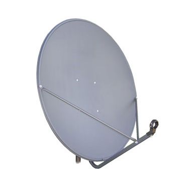
This is the dish I have:


In this pic and in real life it looks tilted backward? What's the definition of 'Flat dish face' ?

I have only taken into account the 3 specifics Dish pointer says I need to know. EG Azimuth, Elevation, Skew
 
In most places in the US, a dish aimed at 97W would look "up" like in the picture above

Can you be more specific about what you call " the antenna branch"? If you mean the arm that holds the LNB, that is not a valid place for measuring the elevation. You'd be better of verifying that the pole is plumb and relying on the elevation markings on the dish mount (and search withing 5 degrees of that marking). Keep in mind that a perfectly plumb pole might bend slignly under the weight of the dish, so it's not unusual to have an elevation reading that's a bit off on the dish mount.
Attached is the Dish Pointer instructions that use the term in question.
QUESTION: Why on earth would dish pointer have installers follow instructions that are false?
 

Attachments

  • IMG_0032.PNG
    IMG_0032.PNG
    134 KB · Views: 211
Top
Flash Sale Popup